The 2020 National Building Code of Canada (NBCC) demands a clear picture of subsurface conditions before any foundation design moves forward, and in Saint-Hyacinthe that picture is rarely simple. We're sitting on the St. Lawrence Lowlands, where the Yamaska River has spent millennia laying down interbedded marine clays, silts, and till over fractured shale. A standard borehole tells you what's happening at one point; a vertical electrical sounding (VES) connects the dots between them. Our crew runs Schlumberger arrays across the food-processing parks along Avenue Côté and the residential expansions near the Saint-Charles River, chasing the transition from conductive Champlain Sea clay to resistive bedrock. For projects where the NBCC triggers Site Class D or E assumptions, the VES data feeds directly into the geotechnical model and reduces the number of invasive borings needed. When we suspect a buried paleochannel cutting across a lot, we pair the VES profile with a few test pits to ground-truth the contact between the organic fill and the underlying till.
In the Champlain clay belt, a VES sounding can discriminate between 5 Ω·m marine clay and 80 Ω·m dry till in a single AB/2 sweep — data that a split-spoon sample alone can't give you.
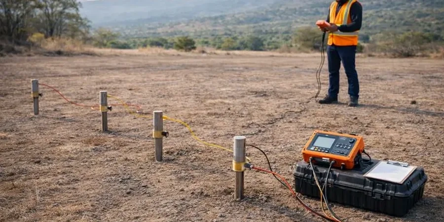
Process and scope
Drive from the industrial district off Route 235 toward the older residential grid around Parc Casimir-Dessaulles, and you'll cross from dense glacial till at a few meters depth into zones where the marine clay runs 20 meters thick before hitting rock. That contrast is exactly what VES captures in a single afternoon. We inject a known DC current through stainless-steel electrodes spaced up to AB/2 = 100 m, measure the potential drop, and invert the apparent resistivity curve to a layered earth model. The resulting 1D soundings—and 2D pseudosections when we roll the array—highlight the resistivity jump from < 10 Ω·m in the saturated clay to > 100 Ω·m in the limestone and shale bedrock. For developers working near the Saint-Hyacinthe–Bagot airport, where the water table sits barely 1.5 m below grade, the resistivity contrast also maps the seasonal saturation front. On larger lots we complement the VES grid with a seismic refraction line to cross-check the bedrock depth and get a dynamic modulus for settlement analysis.
Local geotechnical context
Saint-Hyacinthe's built footprint tells a story: the old city grew on the terrace sands north of the Yamaska River, but post-1960s expansion pushed onto the flat clay plains to the south and east, where the Champlain Sea left its deepest deposits. Those clays are sensitive and electrically conductive, and when the VES profile shows a resistivity trough of 4–8 Ω·m extending past 15 m depth, you're looking at a zone where pre-consolidation pressure and pore-water salinity become critical design parameters. Skip the geophysical stage, and you're betting that the boreholes didn't miss a hidden clay lens or a weathered shale pinnacle that will turn a routine excavation into a groundwater management headache. We've seen projects near the Saint-Hyacinthe campus of the Université de Montréal where the bedrock surface dropped 6 meters over a 40-meter transect—a karstic feature that only the resistivity imaging flagged before the shovels went in.
Common questions
How deep can a VES survey reach in the Saint-Hyacinthe clay soils?
With a maximum AB/2 of 100 meters, the effective depth of investigation typically reaches 15 to 25 meters in the local Champlain Sea clay, depending on the resistivity contrast. That's usually enough to image the contact with the underlying glacial till or the top of the Paleozoic bedrock. If we need to see deeper—say, to characterize a potential aquifer in fractured limestone—we can extend the array spacing further.
What's the typical cost of an electrical resistivity survey for a residential lot?
For a standard single-family residential lot in Saint-Hyacinthe, a VES survey with three soundings and a basic 1D inversion runs between CA$740 and CA$1.270, depending on access and the number of points required. A 2D tomography line adds to the budget but often pays for itself by reducing the number of boreholes needed.
Can VES work when the ground is frozen or covered in snow?
It can, but with caveats. Frozen ground has much higher resistivity, so the surface contact resistance goes up sharply. We use bentonite mud around the electrodes and sometimes pre-warm the contact points. The deeper layers are unaffected by frost, so the data quality at target depth is still valid. For mid-winter campaigns around Saint-Hyacinthe, we schedule the survey for the warmest part of the day and use a higher-power converter to push current through the frozen crust.
How do you calibrate the resistivity data with actual soil types?
The reference range for this service in Saint-Hyacinthe is CA$740 - CA$1.270. The final price depends on the project scope and volume.
Is a resistivity survey enough to determine the NBCC seismic site class?
Resistivity alone can't give you a shear-wave velocity, which is what the NBCC needs for Site Class E or F determination. But when we combine VES with a MASW or seismic refraction line on the same profile, we can correlate the electrical boundaries with velocity boundaries and produce a defensible site classification. That combined approach is what we recommend for schools, warehouses, and any Part 4 structure in Saint-Hyacinthe.